
Early paddle on Oswegatchie River in Wanakena adds to tale of unusually warm winter
Story and photos by William Hill
Without a doubt, this has been an odd winter weather-wise. We had a few big snowfalls, but unseasonably warm weather made short work of the snow. The arctic sub-zero temperatures were also absent (with no love loss over that). The below-zero days we did have were only a few degrees below, instead of 30-40 below. Many of the rivers never froze over, and lakes & ponds were often poorly frozen.
In a normal March, I’m usually snowshoeing and enjoying some sunshine while doing it. Looking back at this week’s “memories” tab on Facebook, last year I went on an annual snowmobile trip with a friend. The year previous I had hiked Tooley Pond Mountain, and the sun was warm enough that I ended up hiking without a shirt. (I’ll spare you from pictures of that one).
This year is a far cry from that. Before St. Patrick’s Day the robins were back, and the woodchucks out of their dens. The waterfowl are out and about on the open waterways.
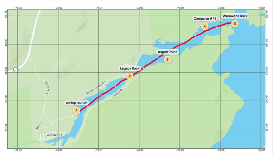
Finally, the stretch of warm, sunny days got the best of me, and I broke out the kayak. I headed for a favorite destination: Wanakena. For no particular reason, the paddle from the Ranger School Road to “Wanakena Rock” has often been my first paddle of the season. This year was the same location, but a month and a half earlier. This chunk of the Oswegatchie River is part of the inlet that flows into Cranberry Lake.
The sun was out and temps in the mid-50s, so it was a great day to get paddling. I put in at a roadside launch, 0.3 miles down the Ranger School Road, just past the former Pinecone Restaurant. As soon as I was on the water, I could hear the Canada geese honking away and saw a few mergansers flying over the water. The camps along the shore were quiet. Usually, someone is mowing their yard or some sort of construction in progress. The only signs of life were a few folks walking around at the Ranger School.
And speaking of the Ranger School, at about 0.75 miles you pass through the narrows. Along here is the start of the Ranger School property. On your left (NW) nestled in the hemlock, is Legacy Rock. This is a small park-like setting overlooking the river. A plaque mounted on the rocks reads “This area has been set aside as a place for quiet contemplation in memory of those who have left a legacy to the Ranger School Alumni Association.”
Past the narrows, the river widens, and the Ranger School campus appears on the left (NW). Across from that is Aspen Point. Here you can find a spur trail that leads to the Big Pine Trail. It’s a fun hike to an old-growth white pine that was spared the lumberman’s axe well over a century ago. This paddle and hike make a nice “surf & turf” outing. There is a small dock there, although winter has left it a bit askew.
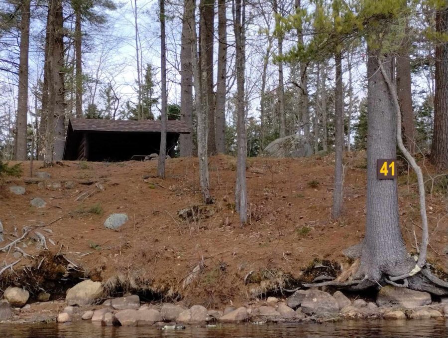
As you follow the flow of the river, you’ll notice campsite No. 41 on the left (NW). This great campsite is unique. Although there are over 40 designated primitive campsites on Cranberry Lake, there are only two with lean-tos, No. 41 and at Janacks Landing at the end of Dead Creek Flow. This lean-to is a popular destination with paddlers, boaters, and hikers, being only a short distance off of the Cranberry Lake 50 trail. It can be reached from a short spur trail off of the Peavine Swamp trail, a 2.8-mile round trip from the Ranger School on trail #1. Campsite #42 is just a few minutes further downstream. It doesn’t have a lean-to, but it’s still a great spot.
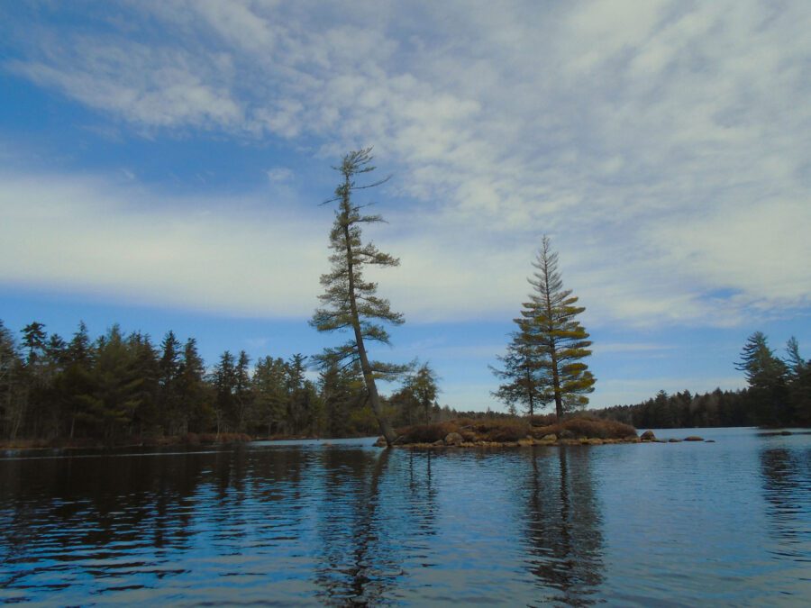
At around 2.3 miles, the river bears right (East) at Flat Iron Point and enters Cranberry Lake proper. A few hundred yards ahead, are two good-sized rocks sticking out of the water. The bigger of the two is known as “Wanakena Rock.” For many years, the rock has had the hamlet’s name and an arrow pointing to the right spray-painted on it.
Over the winter I posted a picture of the rock on a paddling forum. Most people familiar with the area and the lake appreciated the picture. A few, however, were upset and referred to it as graffiti. Possibly in the strictest sense of the word it might be construed as graffiti, but it has served many years as a “road sign” on the waterway. I would be pretty sad to not have it there. It’s not just a rock with paint on it, it’s a landmark, with plenty of local culture attached to it.
After some obligatory pictures (and selfies), it was time to turn back upstream for the return trip. It was definitely a neat experience to paddle that early in the season. There was still some ice in the bays to remind you that it’s still technically winter. The route is about a 5-mile round trip and was a nice warm-up for the coming paddle season. I didn’t have anything to measure the water temperature, but I can assure you it’s pretty close to the freezing point. (Editor’s note: Paddling in cold water should be done with safety in mind.) The trails right now are just a muddy mess, and this was a nice way to get afield without further deteriorating the trails.
I’m not labeling the unique winter to climate change, or global warming one way or another- it was just a crazy weather pattern this year. It happens just like harsh winters do. As Adirondack outdoors folks do, we take the season as it comes and make the best out of it. We trade our hiking boots and kayaks in for snowshoes and microspikes at some point in the year. A little while later, we swap them back. We put away our wool jackets and dig out our shorts and grab the bug spray. That’s the Adirondack way.